Alianza Mesoamericana de Ecoturismo/Mark Willuhn/Palenque/Chiapas/Rio San Pedro/Peten/El Perú/Las Guacamayas/Wildlife Conservation Society/Audubon
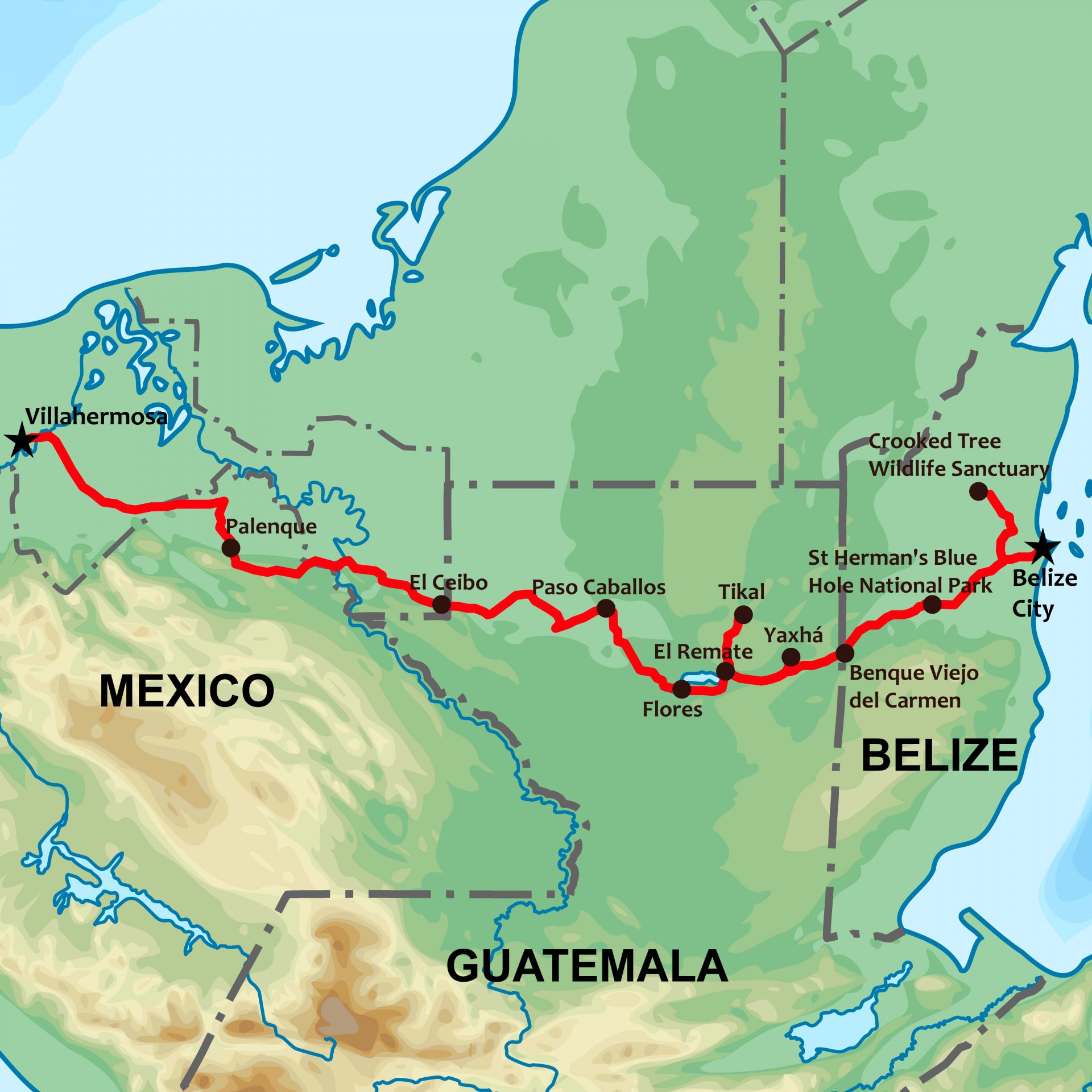
For a number of years I’ve heard about a new border crossing between Chiapas, Mexico and northwest Guatemala in the region referred to as the Petén. While collaborating on some bird watching itineraries in Guatemala and Belize, I heard the “new” border crossing was only 45 minutes from Palenque. This peaked my interest since, if this were true, it could create some multi-country itineraries in a reasonable amount of time to make it attractive to the vacation tight US market.
All of my latino/a colleagues were aware of this border crossing but no one had actually been to the crossing. So I decided that we needed to scout this out and determine exactly where this crossing was, and feasibility of crossing with small groups of tourists. This is the story of how we found a “new” route from Chiapas to the Petén.
Departing Flores/cell phone/data/AC
We started this little adventure from Flores, gateway to Tikal National Park and nestled on the shore of Lake Petén Itzá. We anticipated about a 5-hour drive to the border. The crew was Marlon, Guatemalteco from the highlands who manages indigenous tourism program (www.vivaatitlan.com) , Chalo, legendary conservationist of the Petén, and Sarah from Audubon. The plan was for Chalo & Sarah to drop us off at the border and Marlon & I would take a boat from the border to Las Guacamayas Research Station, run by Wildlife Conservation Society where Chalo would pick us up in two days (www.lasguacamayas.org)
The last reading I got from my weather App before leaving the data network of Flores was 45 degrees Celsius at 1:00 PM. This is about 113 degree Fahrenheit, with nothing but sun. We guessed that it topped out that day at around 48 degrees C or between 118 & 119 Fahrenheit – a new personal record. Note to reader: the hottest months in Mesoamerica are generally the end of April & May, the end of the dry season can be scorching hot. Rainy season usually starts in June and moderates the temperatures. The long drive was uneventful but totally entertaining listening to Chalo’s stories about being a Xatero as a young teenager and endless adventures with jaguars, snakes and narrow escapes.
The Border
We roll into the Guatemalan border town of El Ceibo nearing dusk. We were assured there were plenty of lodging options, which in this case was one sketchy looking hotel. Mexican side had no services. El Ceibo had the looks of one of those places that just happened in the last 10 years. Probably a small community before the border crossing and suddenly it found itself in the need to grow-up. We heard that the power gets turned off at 10 PM. This was not good news as we stood in the dusty road at sunset in 118 degree temperatures. We bought some water and decided to see what El Naranjo, the other town in the area, had to offer about 10 miles up the San Pedro River. The actual border is a bridge over the San Pedro River as it flows into Mexico and Usumacinta River.
El Naranjo had several hotels since this is a ferry crossing for the San Pedro River, commercial hub, markets, and access to Laguna del Tigre National Park. Just as night settled in we found a nice riverside hotel with restaurant (power & AC!). Our work was not done as we needed to find a boat and captain for the following day. We had been making intermittent phone calls to various contacts so we had done some of the legwork earlier. We meet with a boat captain and settled on price and service. When we finally thought we had taken care of everything, it occurred to me that I had made an error. When designing new itineraries, it is critically important to know the exact process when making transitions – in this case we have an international border crossing and transfer from land transportation to boats. I realized that while El Naranjo had the accommodations, we would need to back track by boat to El Ceibo to the place a group would load onto boats. This entailed re-negotiating with our boat captain and setting up an earlier departure time in the morning. We decided that a 4:30 AM departure would get us to El Ceibo and loading area just after sunrise the next morning.
Exploring the San Pedro River
Travel Tip: Invest in a new thermos. I carry a small high-tech thermos that keeps coffee hot for 36 hours. I tend to wake up early and I always have a nice cup of coffee to start the day. In this case, 4:00 AM. The boat was on-time and the first half-hour we are boating down the San Pedro River full speed, no lights, in total darkness. I’m looking for two things – other boats heading up river full speed no lights; and the first hints of sunrise to the east. As it lightens we are pleasantly surprised to find ourselves in a beautiful wetland habitat. Fantastic area for bird watching. We arrive at the loading area at El Ceibo around 5:30 AM and full light. As expected, it’s just a loading area where boats can run up on shore and avoid mud while loading. It looks primitive but functional. Off we go up river to our final destination for the day of Las Guacamayas Research Station, estimated 5 hour trip. So my error the previous day cost us 2 hours of back-and-forth between El Ceibo and El Naranjo. At least we got to pass through the wetland area with good light on the way upriver. Several large flocks of wood storks and hundreds of parrots standout. With hardcore birders we could easily spend 3 – 4 hours in this first section of river.
One reason we think this route has potential is that the northern side of the San Pedro River falls in Laguna del Tigre National Park. While most areas are impacted by human activities, some large clear-cut areas/cattle ranches; there are consistent areas of tropical forest complimented by a good riparian forest generally on both sides of the San Pedro. While the river is wide and deep at the lower sections, there are a few narrow points with rapids. It is also a free flowing river with no upstream dams. So after about two hours heading upstream we come to the first set of rapids. It looks like some easy Class II, simple little shelves dropping about a foot through 2 – 3 meter wide chutes. When I look over the side of the boat I’m surprised to see we are in about 12 inches of water, like how-is-the-prop-still-on-the-motor shallow! Second thing I notice is the bottom is all clam shells. It turns out the shelves are banks of fresh water clams, locally they call them reefs (arrecifes). I’ve never seen anything like it and assuming it’s a great indicator for clean water. We make it through without incident and run into three or 4 more rapids. As these things go, there is one set of rapids that you really depend on the skill of your captain. The river does a sharp left-right combo, shallow, lots of volume. If you knock your propeller off above this combo, pretty dicey if you would make it without capsizing drifting downstream without power. You’ve got to have some adventure in adventure travel!
By now its around 10:30 in the morning and the temperature is back to about 110. We are getting baked but thankful for the breeze from the moving boat. We get to our destination of Las Guacamayas Research Station around mid-day.
I was extremely pleased with this new route and the possibilities it opens up for the region. From Palenque to El Ceibo is a 45 minute drive through some great wetlands and savannahs. The San Pedro River has some great scenic spots, relatively safe, and nice alternative 4-hour boat ride with wildlife viewing compared to a 6 hour drive. Arriving to Las Guacamayas by this route is spectacular and will give participants and appreciation for the bursting biodiversity of Laguna del Tigre National Park.
Currently we are offering this new route through our Tri-national Birding Tour (Mexico-Guatemala-Belize). Look for some new general ecotourism combos since this is the major trading route of the Classic Maya Period with spectacular archeology sites like Palenque, El Perú, and Tikal.
Next blog will be about the ecotourism nirvana of Las Guacamayas Reserearch Station.
Mark Willuhn is the Executive Director for a regional sustainable tourism non-profit called Alianza Mesoamericana de Ecoturismo (AME). You can follow him and AME members at www.exploremesoamerica.com and on Twitter @ExploreMeso Facebook: Explore Mesoamerica
Leave Comment